
What’s Up With El Nino – Winter 2023-2024
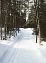
It’s the first day of calendar winter, ski areas are open and we’re coming off last winter which had 90.3 inches of snow (3rd highest on record) and 123 ski days on natural snow (5th highest on record – since 1900). It was the third winter in a row of La Nina. With snow-making at 4 locations in the Metro area now the natural snow isn’t as critical as it used to be although it’s nice to get off the man-made snow loops for variety and lighter crowds.
Unfortunately, we’re heading into a much different winter with El Nino setting in.
Historical El Nino/Neutral/La Nina winters since 1950 can be found on the National Weather Service (NWS)/NOAA/Forecast/Climate Prediction/El Nino-La Nina website and Twin Cities airport snow records can be found on the DNR Twin Cities Climate website.
El Nino winters have had an average winter snowfall of 44.3 inches and average 61 ski days (average winters have about 70 ski days – 2 inches on the ground). The calendar winter average temperature has been 18.8 F in El Nino winters. The ski start is about December 22 in El Nino winters. In the 25 El Nino winters on record there have been 5 with more than 100 ski days. The most ski days were in the winter of 1991-1992 with 125 ski days (Halloween Blizzard of ’91 happened this winter). In the El Nino winters there have been 16 below the 70 ski day average with the lowest in 1958-1959 at 10 ski days.
La Nina winters average 58.8 inches of snow and 90.2 ski days. The calendar winter temperature averages 16.9 F. The average ski start is about December 9. In 25 La Nina winters there have been 12 with 100 plus ski days with the highest in 1964-65 with 131 ski days. Only 5 La Nina winters were less than the 70 ski day average (lowest 21 ski days in 2011-2012).
The 24 Neutral winters had an average snowfall of 54.8 inches and averaged 75 ski days. The average calendar winter temperature for Neutral winters is 16.8 F. The average ski start is about December 13. In the 24 Neutral winters there have been 8with 100 plus ski days with a maximum of 132 ski days in 1950-1951 (highest for any winter). There have been 10 Neutral winters with less than 70 ski days with the lowest at 20 in 1956-1957.
Not only are we headed into an El Nino winter but it appears to be a Strong El Nino winter with an Oceanic Nino Index (ONI) above 2. The ONI is a measure of heat in certain areas in the Pacific Ocean that allow data for each year of record to be compared. (Search online or see the NWS website for more info on ONI).
Previous Strong El Nino events since 1950 have occurred in the following winters: 1982-83, 1997-98 and 2015-16.
The winter of 1982-83 had 74.4 inches of snow and 74 ski days (10 later in March)…both above average. Typically, there are about 1.4 ski days per inch of snow so that should’ve been a 100 plus ski day winter. About one half of the snow fell in March (14.3 inches) and April (21.8 inches) which are not part of calendar winter. The real problem was the warm temperatures. The high temps were at or above freezing from December 21 through December 26. January had 8 days at or above freezing. February was worse with highs at or above freezing from February 10 through February 28 (six days with highs of 40 F Plus).
The winter of 1997-1998 had 35 inches of snow and 47 ski days. There was a good start with 3 to 5 inches of snow on the ground from November 14 through the 26th of November. Again, warm temperatures were the issue. December had 19 days at or above freezing including 5 with 40 plus highs. January had 9 at 32F+ with 3 at 40F+. February had 21 days with at or above freezing highs including 11 at 40F+ and 3 with 50F+.
The winter of 2015-2016 had 36.7 inches of snow and 51 ski days. There were 21 days in December of at or above freezing highs with 11 that were at 40F plus. January had 9 days with highs at or above freezing with 3 that were at 40F plus. February had 17 days with highs at freezing or above and 8 at 40F plus and one at 50F plus.
This November was the 15th warmest on record with an average temperature of 38.5 F. November had the sixth least amount of snow with 0.5 inches. It was the second driest November with only 0.04 inches.
Earlier this week in the Minneapolis Star Tribune Paul Douglas mentioned that some models are projecting maybe only 1 inch of snow between now and Christmas. The NWS Climate Prediction for this winter is warmer with equal chances of precipitation. If its too warm some of that may fall as rain…not good. Since 1950 we have had about 27 years when we could’ve skied in November. That included November of 1991 after the Halloween Blizzard when we had 26 ski days although the grooming wasn’t ready and all of the snow melted near the end of the month. From 1900 to 1950 there were 10 years with possible skiing in November.
From 1900 up to 1950 the average annual snowfall was 40.6 inches. From 1950 through last winter the annual snowfall has averaged 52.6 inches…about a foot more.
It should be cold enough in stretches to make enough snow for the usual full man-made loops to open. Elm Creek had quite a bit of snow made on the lower section today (Friday 12/1).
Its good we have the alternatives now that we didn’t have 20 or so years ago.
See you out on one of the loops.